
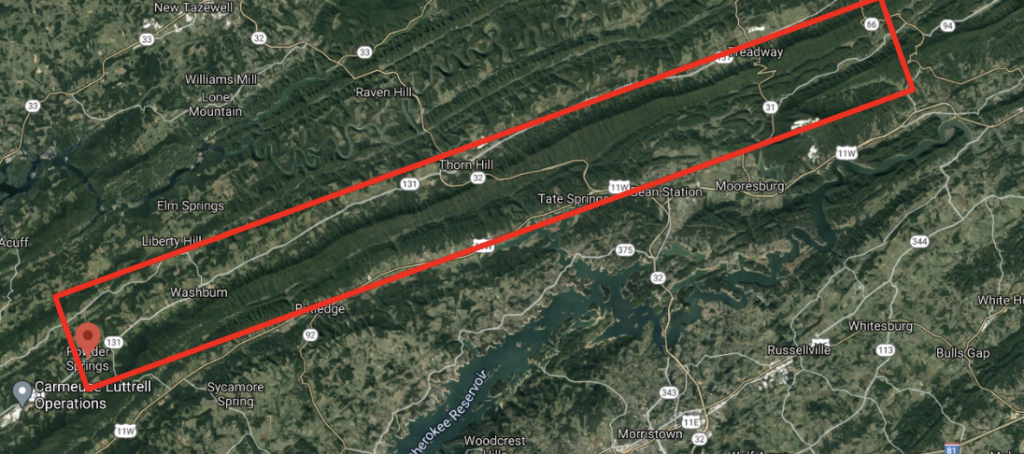

April 2, 1864 – April 4, 1864 – Reconnaissance, Powder Springs’ Gap to Rogersville & Bull’s Gap
APRIL 2-4, 1864.-Reconnaissances from Powder Springs Gap toward Rogersville and Bull’s Gap, Tenn.
Report of Brig. Gen. Thomas J. Wood, U. S. Army, commanding Third Division, Fourth Army Corps.
HDQRS. THIRD DIVISION, FOURTH ARMY CORPS, Powder Springs Gap, April 3, 1864—3 p. m.
GEN.: Both of my reconnaissances have returned. Col. Anderson, with six regiments of infantry and a detachment of cavalry, was sent up this valley with instructions when he reached the forks of the road above Rutledge (one road leads up the valley, the other across the Holston toward Bull’s Gap, &c.) to leave a regiment there; to send three regiments of infantry and a part of the cavalry up the valley to Bean’s Station, and two regiments and the remainder of the cavalry to the Holston. These instructions were carried out.
The citizens informed him that the cavalry had left Rogersville early last week, and they all concurred in the opinion that Longstreet’s forces had been withdrawn toward Virginia. Col. Anderson talked with a Mr. Smith, a well-known Union man above Rutledge, who told him he believed Longstreet’s forces had or were leaving the State, because all the rebel citizens believed it and were much depressed about it.
Col. Kneeler was sent with three regiments of infantry up Clinch Valley. He went up the valley to a point opposite and north of Bean’s Station. He saw no enemy. He was informed that the companies of Home Guards which he encountered there on his former reconnaissance had joined the cavalry at Rogersville, and left with it.
The citizens told him the cavalry left Rogersville last Tuesday, and the reported destination was Georgia. He could obtain no definite information in regard to Longstreet’s movements.
The party which I started to Cumberland Gap on Thursday last [March 31st] has just returned. . . The party passed through Tazewell going and returning, but saw no enemy. Col.’s Anderson and Kneeler report the roads they marched over as execrable.
I am, general, very respectfully, your obedient servant,
TH. J. WOOD, Brig.-Gen. of Volunteers, Cmdg.
POWDER SPRINGS GAP, April 4, 1864—9 p. m.
GEN.: Your note of this day evidently, though dated April 5, is just received. My reconnaissance returned this afternoon, having been absent three days.
Col. Anderson was sent up this valley with order to divide his command beyond Rutledge, sending a portion of it toward Rogersville and the remainder to the Holston, on the road leading to Bull’s Gap, Greeneville, &c.
All the citizens informed him the rebel cavalry had left Rogersville, and all concurred in the opinion that Longstreet’s forces had fallen back, and, as they supposed, with the intention of leaving the State.
A Mr. Smith, a well-known Union man.


